Early today, Dr William Gray and the CSU hurricane forecasting team updated their seasonal outlook and increased the number of storms they expect to form over the Atlantic Basin during the 2010 hurricane season. Their early outlook was for 15 named storms and 8 hurricanes. Here is their most recent forecast...18 named storms and 10 hurricanes. The forecast was based on much warmer-than-normal tropical Atlantic and cooling tropical Pacific likely to transition into a weak La Nina by mid-season.
The following is my previous blog from the start of the 2010 season.
----------------------------------------------------------------------------------
With the massive oil disaster ongoing in the Gulf it is easy to forget that the upcoming hurricane season is upon us. June 1 through November 30 is the part of the year along the East Coast and Gulf of Mexico when we need to keep at least one eye on any tropical weather issues.
Already this year, a tropical storm that formed over the Eastern Pacific made landfall on Guatemala's West Coast and caused considerable damage and loss of life. Right now, there is an area of thunderstorms east of the Yucatan peninsula that is being watched for possible development, though upper level winds will likely keep that from happening.
So as the season begins the folks who make their living making long range hurricane season forecasts have come up with some very worrisome numbers.
Here are some of the forecasts:
Dr Gray and his team from Colorado State University: 15 named storms and 8 hurricanes
NOAA: 14-23 named storms with 8-14 hurricanes.
ACCU-Weather: 15 named storms with 5 hurricanes.
Over the last 60 years the average number of named storms is around 11 with 6 becoming hurricanes.
The reason for the forecast of an above average season, is the weakening of the El Nino in the Pacific and warm Atlantic and Gulf of Mexico water temps. There are other factors but they all point to a season of higher storm frequency.
Even if you don't live right on the coast, a hurricane can certainly cause problems well inland...see Hurricane Hugo 1989 or Opal 1995. That's why we all should put together a ready kit in preparation of the season.
Here is a list of things to consider:
1. Important papers especially insurance contacts and special photos including ID and items that will be difficult to replace like titles or deeds to property.
2. Take video or photos of your property
3. Make plans for your pets
4. Keep a ready bag of clothes for each person in the household.
5. Stock your hurricane preparedness kit: cash (ATM may not have power), batteries, flash lights, battery operated radio/television, bottled water, toilet paper, non-perishable foods, canned goods, can opener, a cooler, candles, prescription medicines ; also diapers, baby wipes, formula, baby food if you have young ones.
Coastal residents I strongly urge you to look into purchasing flood insurance. Do it now because it will likely not be available to acquire if there is an active storm. This is called the "blackout" period when insurance will not be sold.
Be prepared..then enjoy the summer and hope(like 5 out of the last 6 years) the long range forecasts are wrong.
Justin
Tuesday, June 1, 2010
Thursday, April 1, 2010
Happy Birthday TIROS-1
The following is an excerpt of a press release from the NOAA about the launch into space of America first weather satellite. I should of baked a cake. Please remember...I did not write the following but it is good stuff.
50th Anniversary of the Satellite that “Forever Changed Weather Forecasting”
Fifty years ago today, the world’s first weather satellite lifted off from Cape Canaveral, Fla., and opened a new and exciting dimension in weather forecasting.
The first image from the satellite, known as TIROS-1 (Television Infrared Observation Satellite), was a fuzzy picture of thick bands and clusters of clouds over the United States. An image captured a few days later revealed a typhoon about a 1,000 miles east of Australia. TIROS-1, a polar-orbiting satellite, weighed 270 pounds and carried two cameras and two video recorders. Though the satellite only lasted 78 days, its impact is still visible today.
“This satellite forever changed weather forecasting,” said Jane Lubchenco, Ph.D., under secretary of commerce for oceans and atmosphere and NOAA administrator. “Since TIROS-1, meteorologists have far greater information about severe weather and can issue more accurate forecasts and warnings that save lives and protect property.”
Throughout the 1960s, each TIROS spacecraft carried increasingly advanced instruments and technology. By 1965, meteorologists combined 450 TIROS images into the first global view of the world’s weather.
“We could not provide skillful hurricane forecasts without the crucial imagery and data from geostationary and polar-orbiting satellites,” said Chris Landsea, Ph.D., science operations officer at NOAA’s National Hurricane Center in Miami. “Before satellites, tropical storms and hurricanes were often missed if they stayed out over the open ocean.”
When the more advanced TIROS-N satellite series were launched between 1978 and 1981, the name of the spacecraft changed to Polar-orbiting Operational Environmental Satellites, or POES. The POES orbit the Earth at an altitude of about 500 miles and circle the poles once every 102 minutes.
The last of the TIROS satellites, launched from Vandenberg Air Force Base, Calif., on Feb. 6, 2009. This satellite (NOAA-19) and its compliment, a European satellite called Metop-A, provide a complete picture of the globe every six hours.
NOAA operates America’s constellation of environmental satellites – the GOES and POES. Both satellites monitor weather and collect data about the Earth’s climate, and are capable of receiving distress signals from emergency beacons and relaying this information to first responders worldwide. Since 1982, NOAA satellites have aided in the rescue of 250 people on average each year. NOAA satellites also receive signals from remote observation instruments on the Earth including ocean buoys, which provide tsunami warnings.
NOAA: www.noaa.gov
NOAA’s Satellite and Information Service: www.nesdis.noaa.gov
NASA: www.nasa.gov
Friday, March 19, 2010
Spring Fling
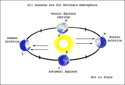
At 1:39 PM EST, on Saturday, March 20th we finally put a steak in the heart of our cruel winter and welcome the glories of spring. At that precise time, the direct rays of the Sun fall perpendicular on the Earth's equator. The poles point nether away or toward the Sun and we have the Vernal Equinox. Yeah!!!
So what the heck is a Vernal Equinox. Well the word Vernal comes from the Latin word vernalis which is from the Latin ver which means spring. Equinox, according to Websters, is an alteration of Latin aequinoctium, from aequi or equi noctor, nox, meaning night. Equi is equal. So we have the Vernal or Spring equal night. Vernal Equinox.
Equal night because the length of nighttime and daylight will be the same, 12 hours, on the day when the Sun and Earth are aligned just right. Check out this diagram to see what it looks like.
I found a really wordy definition from Wiki. It will make your mind go numb but it is fun to read.
At an equinox, the Sun is at one of two opposite points on the celestial sphere where the celestial equator (i.e. declination 0) and ecliptic intersect. These points of intersection are called equinoctial points: the vernal point and the autumnal point. By extension, the term equinox may denote an equinoctial point.
Well the calendar may say that the first day of spring is Saturday but I don't believe spring really begins until they tee it up at Augusta National for the Maters.
Tuesday, March 9, 2010
Bay Lights
Saw the coolest thing last night.
I drive along St. Andrews Bay to and from work. It is usually a spectacular drive with great views. One of the prettiest drives in the world really. Last night, on the way home from work, I took a look toward the water. In the waves right at the waters edge, there was a green glow in each small wave.
I had heard about the sea glowing or sparks coming from the water but I had never seen it until last night. What I saw looked like giant, green glow sticks dancing in the water and in the waves. I had to pull over and get out of my truck and walk right down to the waters edge to make sure my eyes weren't deceiving me.
The was no cloud cover, no moon and no lights to reflect off of the small waves. It was glowing. Green. Fantastic.
I had heard about a plankton or algae bloom but I had to do some digging to find out more.
It is Bioluminescence.
Here is one discription that covers the details.
And...take a look at his video of what Bioluminescence looks like in the water. The video is from Australia. Very Cool.
Tuesday, March 2, 2010
Green Eggs and Such
Born on this date March 2, 1904
Theodor Seuss Geisel AKA Dr. Seuss
So...in his honor I give you this.
I do not like this weather cold.
I don't like it even BOLD.
I do not like it when I am young.
I do not like it when I'm old.
Why must we shiver in the dark?
Why must we shiver in a park?
We shake our souls in this cold air.
The temperature falling.
We sit and stare.
Water freezes in a puddle.
To warm it up,
We must huddle.
Cuddle and huddle on a frozen puddle.
Please warm it up... and on the double.
Where is this Earth of Warming Climes?
I cant not find it in these rhymes.
The Warming Earth might roast and flood
But not this year...this Winter's crud.
I do so hope for warming soon.
I can not wait for the month of June.
We will warm it up in Spring?
The warmer days that Spring flowers bring.
Kids and moms and dads do search
For a beach chair to sit and perch.
The schools will break and coastlines call.
This Winter's weather has still stalled.
We grumble bumble stumble and fall
You cant play with a frozen beach ball.
IF Global Warming is meant to be,
We all must drive our SUV.
Oh! This chill I have no use.
So... Happy Birthday Dr Seuss!!!
Tuesday, February 23, 2010
En-Lightning Facts
Early Monday, a small quick moving thunderstorms raced across the Florida Panhandle.
The storm was not all that impressive unless you were one of the four Air Force Airman who were struck by lightning during the storm. The link provided will take you to a story with coverage of the strike.
http://www.panhandleparade.com/index.php/mbb/article/four_tactical_air_control_party_members_struck_by_lightning/mbb7721583/
This event provided me with some motivation for today's blog.
Lightning facts:
The distance you can hear thunder is between 2 and 12 miles away from the lightning bolt that created the thunder. Wind speed, wind direction, terrain, clouds and trees can be factors in the how far from the bolt you can hear thunder.
Thunder is generated along the length of the lightning stroke as the atmosphere is heated by the electrical discharge to the order of 55,000 degrees F. The heating of the air around the lightning produces a shock wave, which then changes to a sound wave as it moves away from the lightning.
The average lightning bolt is 6-8 miles long and can easily travel 25 to 40 miles across the sky prior to turning downward toward the ground.
The 30/30 Rule:
This safety rule teaches us that when you see a lightning flash, count the seconds to the thunder, then divide the number of seconds by five (sound travels one mile in five seconds) to give the distance in miles between you and the lightning. For example: you hear thunder 30 seconds after you see lightning, the distance is may be 6 miles. Thus the reason for the first number of the 30/30 rule. You will be safer beyond 6 miles from an active thunderstorm. Wait 30 minutes after you hear the last rumble of thunder before you venture out to do outdoor activities.
As we head into the spring and summer thunderstorm season, keep these facts in mind and keep it safe.
Thursday, February 18, 2010
Semi-Meaningless Trivia
I heard on a news report that on this date in 1979, snow fell for about 30 minutes on the Sahara Desert. It was reported in Southern Algeria and it is the only snow on record for the Sahara.
Now, I love a good piece of weather trivia and something like this got me thinking about February 18. Did anything else of consequence happen on this date weatherwise or otherwise?
Weatherwise:1972 - Rainier Paradise Ranger Station, WA establishes the U.S. record for most snow in a 12-month period with 1224.5 inches from February 19, 1971 through February 18, 1972.
Otherwise: Sharing a Birthday today.
Mary Tudor 1516... Queen
Enzo Ferrari 1898... Varooooom
Yoko Ono 1933... hmmmmm
Dennis DeYoung 1947 ...Come Sail Away
Juice Newton 1952 ...Break it to me...
Robbie Bachman 1953... BTO Takin Care of Birthdays
John Travolta 1954 ...Welcome back
Vanna White 1957 ...Turn a letter please
Matt Dillon 1964 ...Dupree's best friend
Dr. Dre 1965 ...Straight out of Compton
Molly Ringwald 1968 ...42 Candles
Some important "On this date in history"...
1861 - In Montgomery, AL Jefferson Davis was inaugurated as the President of the Confederate States.
1885 - Mark Twain's "Adventures of Huckleberry Finn" was published in the U.S. for the first time.
1953 - Lucille Ball and Desi Arnaz signed a contract worth $8,000,000 to continue the "I Love Lucy" TV show through 1955.
1977 - The space shuttle Enterprise went on its maiden "flight" sitting on top of a Boeing 747.
1968 - David Gilmour replaces Syd Barrett in Pink Floyd. Barret had checked himself into a psychiatric hospital and then gone into seclusion.
1974 - KISS released their first album "KISS".
KISS Store
The number 1 song on this day in 1984 Karma Chameleon by Culture Club...ouch
Lastly,
2001 - NASCAR driver Dale Earnhardt, Sr., was killed in a crash during the Daytona 500 race.
Sure miss him.
We will see what tomorrow holds.
J
Tuesday, February 16, 2010
Climate IS Weather
You know, I have been working in and looking at climate for 25 years. While I admit I have some reservations about the global, socio-economic, geopolitical, worldview of man-made Climate Change, I am open to the science and scientific proof. Evidence always persuades me more than agenda.
For example, there is tangible evidence that glaciers advanced to Southern New England and then retreated. These glaciers retreated because it got warmer. There is also unique evidence that there was a long period of warmth that covered the Earth for centuries about a thousand years ago. Then it got colder.
Climate is described as the historical record of average daily and seasonal weather events. Seasonal weather events occur in cycles and much depends on the sun and oceans and their effects.
So, I want to share with you a video presentation from a meteorologist with a weather company called Accu-Weather. There are some very pointed and poignant pieces of information in his discussion. It is not intended to sway... you just inform you. The video is about 6 minutes.
Enjoy, J
Climate Video
Friday, February 12, 2010
When Winter was Winter
So while some of us dig out and some of us just dig it and some of us(me) missed it. The Winter of '09/'10 will be one for the record books. I wont get into to all of the snowy details. But I wanted to bring up a Winter Storm that hit the Eastern U.S. February 12-14, 1899. A storm simply known as "The Snow King".
Before Willard Scott, Al Roker, Jim Cantore or The Snowpocalypse, a winter storm hit the United States east of the Rocky Mountains with the fury unmatched in scope and scale. The winter weather records that were set during and after, in some cases, still stand to day.
Here is a list of some of them:
- Cape May, New Jersey: 0 °F
- Tallahassee, Florida: −2 °F (only sub-zero temperature in Florida)
- Atlanta, Georgia: −9 °F (coldest ever in Atlanta history since at least 1874)
-Sandy Hook, Kentucky: −33 °F
-Minden, Louisiana: −16 °F
-Fort Logan, Montana: −61 °F
-Camp Clark, Nebraska: −47 °F
-Milligan, Ohio: −39 °F
-Lawrenceville, Pennsylvania: −39 °F
-Santuc, South Carolina: −11 °F
-Erasmus, Tennessee: −30 °F
-Austin, Texas: −1 °F
-San Antonio, Texas: +4 °F
-Monterey, Virginia: −29 °F
-Dayton, West Virginia: −35 °F
-Washington, D.C.: −15 °F (still the all-time low temperature within the D.C )
Other weather records of note and weather anomalies:
-Cape May, New Jersey recorded 34" which is the highest single storm snowfall total ever in New Jersey
-The Port of New Orleans was completely iced over by February 13, with ice floes reportedly floating out of the Mississippi River into the Gulf of Mexico.
-Also on February 14, the low in Miami was 29 °F
Here is a great picture from the Baltimore area in the wake of the Blizzard of 1899.
CLICK HERE....look familiar!
BTW 33 days until SPRING!!!
Monday, February 8, 2010
It's Snow Joke
Another 10 to 20 inches of snow is on the way to the Mid-Atlantic where 20 to 30 inches fell over the weekend. Washington, Baltimore, Philadelphia have been hit by two 20"+ snowstorms this winter. This is extremely rare maybe once in a hundred years to get two major snowstorms in a single winter for those cities. Now another winter storms is heading toward the Mid-Atlantic...this may wind up being the all-time snowiest winter for some East Coast cities.
Today there was heavy snow in Tennessee, Northern Mississippi and Alabama. There is a possibility for additional snow in the Southeast late Tuesday and parts of the Southeast will see some sleet and or snow on Friday with additional chances for cold weather events for the remainder of February. Click here to see the outlook for the next 6 to 10 days.
So here is the Didjaknow Factoid.
Let's say you have a standard driveway that is 20 feet wide by 40 feet long. Now, if you live near Dover, Delaware you just got about two feet of snow. You are old fashioned and you use a good ol' snow shovel like dad used to have.
Do you know how much weight you lifted by the time you cleared that driveway?
Well, the liquid content of the weekend snow was about 10:1. This means that for every 10 inches of snow you will have about 1 inch of liquid equivalent. That drive way has about 1600 cubic feet of snow. The weight of a cubic foot of heavy wet snow is about 12 pounds. By the time you cleared that driveway...you have lifted about 19,200 pounds of snow!!!!!!!! No wonder snow blowers are so popular.
Sunday, February 7, 2010
Super Bowl...Super Weather
Well it's Super Bowl Sunday and while those of you in the Mid-Atlantic dig out, Florida is looking good today and the weather in South Florida will be nice for the Big Game. At kickoff the weather in Ft Laurderdale will be Clear with a light Northerly wind and a temperature in the Upper 50s.
Usually the venue for the Super Bowl is in cities where the weather won't impact the outcome of the game. But in 2007 when the Colts last played in the Super Bowl it was also in South Florida and it rained. The most rain ever during a Super Bowl...nearly an inch. And... the only time out of 10 Super Bowls hosted in Miami/ South FLA that it has rained.
Once domed stadiums were built, the NFL saw the advantage to moving the Super Bowl inside and avoid and weather problems. 17 of the 43 Super Bowls that have been played have been contested in domed stadiums. This is a good thing considering how bad the ice storm was in Atlanta when they played the Super Bowl there in 2000. At game time in Detroit, home of Super Bowl XVI, the outside temperature was 16 degrees.
So, just looking at the games played outside, I would have to say the weather for Super Bowl VI between the Dallas Cowboys and the Miami Dolphins had the worst weather. The Game was played at Tulane Stadium in New Orleans and the Kick-Off temperature was 39 with overcast skies and windy conditions. Two Years earlier, Super Bowl IV was also played at Tulane Stadium under a tornado watch.
Before the Super Bowl was conceived, pitting the AFL(AFC) and NFL(NFC) champions, there was the NFL Championship. That game was not played at a neutral, fair-weather stadium, it was typically hosted by the team with the best record. on December 31, 1967 Green Bay Packers hosted the Dallas Cowboys for the NFL Championship. The game was played with a temperature of -13 and a wind chill temperature of -46...ah that's when men were men and they played football outside. :)
Enjoy the game...don't eat too much.
P.S. Here is some Super Bowl trivia you can use to stump your office with Monday. Four Colleges have have produced three different starting Super Bowl QBs. Alabama: Starr, Namath, Stabler...Notre Dame: Lamonica, Theisman, Montana...California: Kapp, Morton, Ferragamo(transferred to Nebraska) and Purdue: Griese, Dawson and tonight's starter Drew Brees.
Friday, February 5, 2010
National Weatherperson's Day
I have to admit this day kinda snuck up on me. But as I write this, I am enjoying a delicious cup of Blue Bell Homemade Vanilla Ice Cream. More on the sweat treat later. On to this National Weatherperson's Day.
On this date February 5, we commemorate the birth date of John Jeffries. Born in Boston in 1741, Jeffries would be educated in Great Britain and return to Boston as a physician and surgeon. He treated one of the Americans wounded in the Boston Massacre and would later testify for the defense at the famous trial. Loyal to the King he would be exiled to England and left the Colonies to become a surgeon for the British Navy.
OK... so you are saying "what in the world does this have to do with me eating Blue Bell Ice Cream ?"...patience please.
Jeffries was an avid weather observer, one of the first in America. In fact, he began taking daily weather observations in Boston in 1774. When he was exiled to England, he took his passion for weather and put it to use for the English as a weather forecaster.
Jeffries was also a balloonist and combined the two intrests to take the first high altitude weather observation. In November 1784, Jeffries along with French balloonist Jean Pierre Blanchard, rose to an altitude of 9309 feet above London. The pair would later take the first aerial crossing of the English Channel in 1785.
So today we give homage to the weather forecaster and their public service. National Weatherperson's Day established to recognize the meteorologist, weather forecaster, weather observer, weatherman, or any of my brothers!!! :)
OK... on to Blue Bell. Each year, on National Weatherperson's Day, the Blue Bell Ice Cream company sends out their reps to TV stations all over the country (including the one I work at) and gives the meteorologists ice cream as a way to say "thanks". It is also very savvy marketing because TV people are usually very eager to take free things and will give quality on-air exposure to the Blue Bell folks for some tasty frozen dessert items.
I found these neat things on About.com that your can do as a family for some National Weatherperson's Day fun! Click HERE!!!
So that's it, my ice cream is all gone, and this entry is all done.
Thursday, February 4, 2010
Blizzards
Winter storms are fun...from a distance. I would compare them to hurricanes to the disruption on everyday life. Unless you have nothing else to do but sit and watch it snow, winter storms are miserable. Having lived through a few doozies while we lived in Connecticut, I can say that shoveling a 180 foot driveway covered in 20 inches of snow is bit bothersome.
The trouble these storms bring: to work and school, traffic and travel... not to mention the panic and hysteria at your local grocery store...like you will never ever be able to buy milk and bread again. Snow removal, sanding the streets, salting your sidewalk...yuk.
I bring this up because a few of you, some family and friends, are about to get smashed by a winter storm that will rival any this year and may be a record breaker for some. There are winter storm warnings and blizzard warnings up, right now, for the Delmarva region. TWO FEET of snow is likely going to be on the ground by the time it is all done by Saturday. All I can say is WOW. The combination of cold air and a wet El Nino weather system coming up from the Gulf of Mexico will produce some prodigious snow totals. I had an idea it was going to be a blockbuster but this will shut down part of the Mid-Atlantic for a while.
For you weather history buffs like me :) ...this is a period when some of the biggest winter storms of all time have hit the East Coast. Feb 6-9 1973, Feb 6-8 1978, Feb 18-19 1979, Feb 11-12 1983. "All Y'all" in Georgia... you may remember that '73 storm. Shut down the state and most of South Carolina for a better part of the week.
Anyway, for those in the snow bulls eye, good luck, I am linking the bulletin text from the National Weather Service office from Philly....be afraid, be very afraid. ;)
Wednesday, February 3, 2010
The Middle of Winter
I will admit, I have a bit of Groundhog Day hangover( but then again who doesn't) but it is time to move on to the second half of winter. For most of the United States, spring can come none too soon. Today was a nice day where I live, Panama City Beach, the sun was shining brightly with a bit of a cool wind. This has been a really rough winter. California and Florida floods. A killing Florida freeze. Heavy snow in the Southeast and mid Atlantic region. Now we look up and here comes another blockbuster storm.
By the time the upcoming weekend is over, there will be flooding rain from Texas to Florida along the Gulf Coast. This storm will become a big-time snow maker for the Mid-Atlantic and Central Appalachians with 1-2 feet of snow possible in places. And down south, 3-6 inches of rain will inundate the Coastal regions of Mississippi, Alabama and Florida. This will be a real mess. The good news is that it all clears out for South Florida in time for the Super Bowl.
So here we are, at the midway point of winter...with 45 days before spring begins. I don't know about you but I am hoping that the fur ball in Punxsutawney PA is way off. Bring on spring and bring it on NOW.
Oh yeah, by the way, Daytona 500 in less than 2 weeks, pitchers and catchers report to Spring Training in about 2 weeks and Algonquin College in Nepean, Ontario Canada will kick off Spring Break here at Panama City Beach on February 15th. Yes order will be restored...I think I can hear the azaleas buds trying to bloom.
Tuesday, February 2, 2010
Groundhog Day
Ok, so there is far too much attention given to small furry rodents and their meteorological acumen. But, having said that, I find myself more and more interested in the coming and goings of Punxsutawney Phil and the rest of the groundhogs around the country.
In case you missed it, Punxsutawney Phil was snatched from the warm confines of his hovel by strange men in top hats and tails and thrown into the spotlight of local and national news reports. This yearly ritual had us all glued to the TV and anxiously awaiting his observation. (Well maybe not glued) And, according to the little man staring at Phil, the groundhog saw his shadow.
Now, when the groundhog sees his shadow on Groundhog Day it means that Winter's grip will hold for 6 more weeks (which is when winter actually ends). If the groundhog does not see his shadow he will scurry about... sure that winter would soon be over... an Early Spring. But when I looked at the weather reports from the surrounding cities near Punxsutawney, PA , all of the reports showed cloudy and overcast conditions with light snow. HOW can he see his shadow if it was cloudy? hmmmm! We will see.
Weatherwise the pattern that has been persistent this winter, dominated by the El Nino, will continue through the month of February. That means cool conditions East of the Rockies and several wet weather systems.
Groundhog Day is a tradition that was created in the 1700s by residents in Pennsylvania of German ancestry. Germans had long celebrated Candelmas Day, winter's halfway point, and brought the tradition to North America. In Germany, they looked to the badger but Pennsylvania had groundhogs...and thus began Groundhog Day.
Monday, February 1, 2010
Groundhog Eve
Well just like the billion or so other people writing a blog, it is time for me to get into the 21st Century. I kind of got a transistor mind in a microchip world but I wont let that stop me. Blog posts here will mostly be about the weather. Write about what you know. If I don't know about it... I will do my research and share it. If it still doesn't make sense then...well...cross that bridge later.
Tomorrow is Groundhog Day. As a professional meteorologist I used to hate the day...thought it was so silly. But I have come to love the furry little rodent and the hype that goes along with him(or her). There are groundhog days all over North America but of course the real deal is Punxsutawney Phil at Gobbler's Knob, PA.
The forecast for Phil is cloudy with a chance for snow. In the past that type of weather hasn't always produced a "Did not see his shadow" report... so we will see. As far as the weather here in Northwest Florida, we should see some clouds and a slight chance for rain so any groundhogs around here should not see there shadow. You know what that means... An early spring...YES!!!
As you wait for February 2, check out the groundhog "Imposters"...
Subscribe to:
Comments (Atom)
